Walking the Shin-etsu Trail: Part 1

One of Japan's newest and most exciting multi-day hiking routes, the Shin-etsu Trail extends some 110 kilometers along the Nagano-Niigata prefectural border. First established in 2008, the trail is divided into ten distinct sections and covers a wide range of terrain, from craggy mountain passes to lush forest and even areas of marshland, with frequent views of the surrounding peaks and valleys.
After languishing on my hiking to-do list for far too long, I was delighted to finally take on the first two sections of the trail this summer, leading to a challenging but also hugely enjoyable overnight trip deep in the Japanese backcountry.
With the trail covering such a large area - much of it quite remote with limited or no access by public transport - it could easily seem like too daunting a prospect for all but the most serious of hikers. Fortunately however, visitors can count on solid support and information from the Shin-etsu Trail Club, a non-profit organization dedicated to maintaining and promoting the trail, while coordinating with the local community to provide accommodation and access. Easily reachable through their website and with guidance available in English, I strongly recommend the club as a first point of contact for anyone interested in taking on the trail.

Day 1 (8.5 kilometers, six hours)
My first day on the trail began with an early ride on the Hokuriku Shinkansen from Tokyo to Iiyama, taking around 100 minutes. Arriving into the station, I took a final opportunity to stock up on snacks at a nearby Tsuruya supermarket before jumping in a taxi for a 13-minute drive to Madarao Kogen - a small resort town at the foot of a ski slope where I would begin my trek.


Lacking any kind of shade, this initial push would soon prove to be one of the most challenging sections of the two days - a hot, cardio-intensive struggle that left a concerning dent in my water supply. Finally however, a series of switchbacks brought me to the upper currently disused chairlift station, and after a quick pause to enjoy the view, I slipped gratefully through the tree line and into the shade.


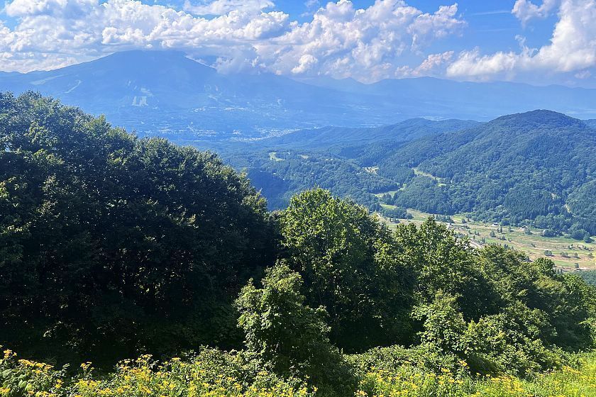
From here the path began to level out, and I soon arrived at a small clearing identified by a post as the summit of Mount Madarao (1382m) and the Shin-etsu trail's official starting point. Here the view was quite obscured by treetops, but this was soon remedied with an optional 10-minute detour to the nearby peak of Daimyojin-dake.


Doubling back to the summit, it was time to continue down the ridgeline towards the Manzaka Pass, my second waypoint of the day. The trail soon led onto a second, broader ski slope, then narrowed into a grassy pathway before depositing me on a paved road. A few steps further along on the opposite side, another signpost identified this as the Manzaka Pass and pointed into the trees beyond.


The following section of wooded trail was relatively gentle, leading slightly uphill for a little over half a kilometer with a few switchbacks, emerging onto the Hakama Wetlands. Known for its many beautiful alpine flowers in the spring months, the marsh had largely dried out in the summer sun, with vegetation limited to thick brush, bracken and tall grass.


An abrupt left turn marked the beginning of the day's second ascent, this time of Mount Hakama-dake (1135m). This proved to be another challenging section, with frequent switchbacks and undergrowth pressing claustrophobically onto the path from both sides. Before long however, a cool breeze and a sudden shift to beech forest signaled my proximity to the summit.
As with Madarao, the summit turned out to be little more than a narrow clearing, but the treetops thinned out a little further along enough to give me another terrific valley view.


The steep descent from Mount Hakama-dake required some careful footwork, but it was still a relief to be going downhill. By now, the day's exertions were catching up with me, my water had dwindled to a last couple of mouthfuls and I found myself constantly scanning for the next signpost. Finally, I emerged from the treeline and onto a gravel road, with just about enough energy for the final push to my campsite for the night.


Set in a pleasant grassy space around the pond that gives it its name, the Akaike Campsite turned out to be one of the highlights of my trip. After setting up my tent, preparing a simple meal on a small stove and finding drinkable water in the site's single, lodge-style building I was more than ready to turn in, but my night wasn't quite over yet. As dark set in, the cloudless sky overhead filled up with bright stars, and later a storm in the next valley sent sudden flashes of light across the mountain ridges.

Day 2 (11.2 kilometers, five hours)
Making an early start the next morning, I scoffed down a quick breakfast of coffee and energy bars before breaking camp and continuing on what promised to be the easiest overall section of the trail. From the campsite, the path led southwest on a gentle slope through beech forest to the Numanohara Wetland.
Hikers can choose to take a short diversion here to explore the marsh, but in the absence of any seasonal flowers I decided to push on.

Making my way out of the marsh, I found myself briefly walking along a paved road, where I encountered the first public toilet I had seen so far before veering back into the woods. A zigzagging path led mostly uphill for around 50 minutes, bringing me to the shores of Lake Nozomi.


By now, what looked like thunderclouds were beginning to darken the sky overhead, so after a brief pause to enjoy the lake with Mount Madarao neatly framed in the background, it was time to push ahead for the final peak of this trip - Mount Kenashi (1022m). After 50 minutes or so of hiking along a fairly gentle series of switchbacks, I arrived at the thickly wooded summit. Although there wasn't much to see here, gingerly taking an unmarked path further along to the right paid off with a wonderful view down into the valley.


From here the path turned steeply downhill through beautiful larch forest, requiring some careful footwork to avoid catching a foot in its twisted roots. After a few twists and turns I emerged at a small pond called the Wakui Shin Ike.

By now very much on the home stretch, I paused to refill my water bottle at a small spring before making a final push along a winding gravel road. The forest quickly gave way to farmland, and I was soon passing tall patches of corn and other vegetables.


At last, a handful of quaint country houses signaled my arrival at Wakui Village and the official end of section two. Arriving at a main road and with decent cell coverage, I was soon able to arrange a pickup by a local taxi company - if for any reason this hadn't been possible, my fallback option would have been to hike on to Kita-Iiyama Station (around one hour on foot), just one stop from Iiyama Station on the JR Iiyama Line.
My first two days on the trail had been every bit as challenging and enjoyable as I had expected. In my next blog, I'll continue my journey from Wakui Village to the Sekida Pass, some 21 kilometers to the northeast.

Links and Resources